
When drones are mentioned, the images of tiny toy planes zipping around in the air are usually what people think of first.
Truth is, they are demonstrating their usefulness to the mining industry, mapping and surveying underground. Newmont Goldcorp has been using one purpose-built drone to help them re-map a mine near Timmins and so far, it is proving to be both fun and critical in collecting data.
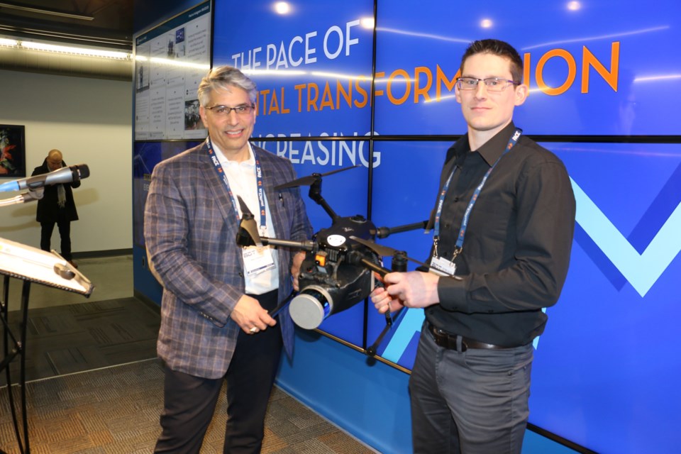
SafeSight Exploration of North Bay is working at the Newmont Goldcorp Hoyle Pond mine in Timmins to map out the entire mine, including every drift, raise and stope, using a drone equipped with LiDAR (Light Detection and Ranging).
The drone was presented during a talk by Goldcorp Porcupine Gold Mines’ chief surveyor, Dave Poulin, and SafeSight president Mike Campigotto at the second annual Beyond Digital Transformation conference, held in Sudbury on Feb. 6 and hosted by Partners in Achieving Change Excellence (PACE).
“We don’t know how many of you get to fly a drone around at work, but we do, and it’s a lot of fun,” Poulin said in his presentation at NORCAT.
He added every level of management needs to understand what they are doing and everyone wants to get involved. Little ideas, like using drones, will come back to help the company if staff are engaged and working together.
The drone is being used to provide 3-D mapping accurate to one-sixteenth of an inch. In remarks to Sudbury Mining Solutions Journal, Poulin said the idea of using the drone was to provide a new, fast and accurate way of providing an up-to-date version of the mine map that not only showed the layout of every drift, but also recorded whether there are protruding rock outcrops in the tunnel walls, the sort of thing that might cause a problem for remotely operated trucks or scoops.
Low-hanging ventilation and cables would also be recorded. Poulin said it allowed areas of the mine to be mapped without sending a survey team into an area of dangerous ground conditions or poor ventilation. The LiDAR survey records 600,000 points a second as the drone moves through a drift.
The system also allows the mine to remotely investigate any ground failures or unsafe areas of the mine so as to help speed up remediation. SafeSight’s Campigotto explained the drone is mostly a stock model that can be bought commercially. The company custom 3-D printed the undermount for the camera, along with a few other internal proprietary parts.
He admitted the process had a few setbacks. The first day in the mine he showed up with the latest model drone, equipped with the newest 3-D camera and 360-degree LiDAR devices.
“Goldcorp approached us and said, 'Can you do this?' We said 'yes.' And we got there and we couldn’t take off,” Campigotto said. “They didn’t fire us. I think that is a testament to their leadership and the culture of their organization. They said, 'What can you do?' We picked the damned thing up and walked around and eventually we got the scan we were looking for,” he said.
The problem was connected to underground air pressure, and was resolved in a couple of weeks.
“Which is exactly what an innovation organization has to do. You must respond rapidly to your failure,” Campigotto added. “Had they (Goldcorp) been more traditional and said, ‘Well, I guess the technology is not ready; see you later,’ we would not be where we are today,” he said.
He added Goldcorp’s willingness to work with them and see the fails as chances to improve is a testament to the company. They are allowing them to work on improving the product and see the advancements on their side as opportunities for them.
“Few are willing to do this,” Campigotto said. “They wanted to make this an iterative process, and get results with each iteration. The improvements are small, but each one has a step-change effect on the industry.”
Poulin endorsed that and said dealing with failure is part of the process. He said it is not a necessary evil, because it is not an evil at all. It is the byproduct of doing something on the leading edge.
“Failure is part of your life,” Poulin said. “It’s everything we do, from the time you were a child to the time where you develop your career and all the way through. You’re going to fail at something.”
He said the solution is to keep moving forward with your vision. It’s going to take time and effort, but you can’t make it hurt the business, either.
Campigotto said the innovation for drones and mines is just beginning. He said the current process requires people, or drone pilots, operating the drones.
“We want to improve that to article avoidance,” he said, programming the machines so that they can fly without bumping into the walls or hitting anything. “That step will be to assist the pilot to make it easier to fly,” he explained.
In later comments, he said they are working on allowing operators to fly underground drones at surface. Currently, operators have to be underground with the machine, as drone technology required the operator maintain a line of sight on the drone. They can get the drone to fly out of sight for a limited distance now, but hope to expand it later this year.
The company has a roadmap on the drone’s current capabilities and is using it to go forward with improvements. SafeSight is working with other companies to apply it in different areas, as well as develop it for mine rescue, equipping it with tools such as poison gas sniffers to alert rescuers.
“Then we will move to autonomy, which will allow the drone to receive a flight path and execute. Then we will add AI (artificial intelligence) to allow the drone to think through where it needs to fly,” said Campigotto.


