
When you think of an unmanned aerial vehicle (UAV), if you’re picturing a day when you can have a drone deliver pizza to your door, you might be disappointed.
“I hear all these cool, great things,” said David Tisseur, owner of Canadian Drone Service in North Bay. “Yeah, I love James Bond movies, too, and I wish my car had an ejector seat, but the reality is, it ain’t gonna happen.”
But drones still have practical, useful applications, and industry is starting to take notice.
Tisseur has 25 years of experience in industrial maintenance, and worked in Europe and Canada before being lured to the North seven years ago. His specialty has been thermal imaging, but about a year ago, he decided to expand his scope of work.
Inspired by a 2012 incident during which a tanker truck tipped over, dumping formaldehyde into Trout Lake, he figured there was a better way to survey damage that had been done. An operator can be sent in to survey the damage, but that surveyor comes back carrying toxicity from the spill with him. But send a drone in, Tisseur reasoned, and operators get a good visual inspection without the toxic side effects.
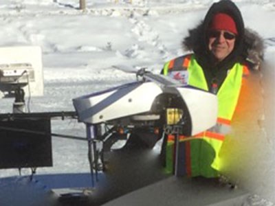
He acquired an ING Responder, a made-in-Canada flexible rotary wing UAV with a capacity for a 26-pound payload and operating time of 40 minutes. Equipped with a Flir A65 thermal imager, the drone can detect hot spots in a variety of scenarios.
“What I can do with that specific piece of equipment, I can see hot spots in electrical components, I can see water damage in a roof membrane, I can see a broken tile in a septic system,” Tisseur said. “There’s a variety of applications for thermal imaging, and that’s where I started to focus my business model.”
But he soon found that interest in the technology went beyond residential applications. Industry was looking to three-dimensional geographic information system (GIS) mapping to plan out operations.
“That traditionally catered toward mining companies or developers that, before they put a shovel to ground, want to have a better understanding of the topography of what they’re working on,” Tisseur said. “In a sense, it’s a smart dollar spent before you send your engineers out, or before you do your surveys. Really, where you’re planning on doing your work.”
The drone brings back large amounts of data, film and images, which can then be used to answer questions to underlying problems instead of relying solely on human assessment.
“It’s a snapshot of information,” Tisseur said, “but it’s real information.”
Tisseur has been operating the drone for about a year, and recently hired on two employees, with backgrounds in chemical engineering and environmental sciences, respectively, to add environmental science applications to his list of services. He’s also acquired a Nikon D810 digital camera to take video and still images.
He foresees future applications in forestry, power generation, agriculture, or mining, such as in the use of settling ponds.
“Not only can I see the sediment on the inside of the settling pond, I can see if that settling pond has leached its contents into the ground,” Tisseur said. “That technology really lends itself to those diagnostics.”
There are other applications, too — Tisseur has received requests for photos of family cottages and weddings — and he’s open to ideas. He considers all of Northern Ontario his catchment area.
“We’ve been approached for a variety of things, and we haven’t turned anything down yet,” he said.
Tisseur charges $300 an hour or $550 per hour for UAV mapping, which is in line with industry guidelines. Regulations set out by Transport Canada require Tisseur to keep a record of his flight logs and times, but otherwise, the end user takes ownership of all the data collected on a flight.
Along with professional services, Tisseur is eager to engage and educate the community on the versatility and usability of drones. In February, during the 2015 Special Olympics Winter Games, Tisseur volunteered his time and equipment to film the events, recruiting local students from a high school robotics team to help with security. He’s additionally taken footage for the City of North Bay, and said he’d love to capture some of the North’s more well-known landmarks.
There’s still a fear amongst some that drones are being used for more nefarious purposes — reading people’s body temperatures or peeking into bedroom windows — but Tisseur said that Big Brother mentality is largely unfounded.
“We’re here, we’re part of the North, and we want to engage the community,” Tisseur said. “We want to apply our service to as many applications as possible. We’re ahead of the curve.”


